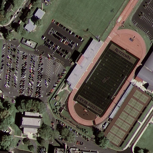
Here's looking at you, kids: GeoEye-1 releases its first image
A high-resolution commercial satellite launched in September returned its first ultra-sharp image this week.
Upon opening its various eyes on Tuesday at noon (EDT), the first thing the GeoEye bird saw was the campus of Pennsylvania's Kutztown University, where the day was bright and clear and your best hope of finding a parking spot was out by the stadium.
It's nice to see that parking's improved since the last time Google Maps' satellites passed over the region. Back then, the stadium was half-built and the eastern parking lot didn't exist yet -- though if you check Google Maps you'd have to squint to see all that. For now.
Google is the sole online-mapping customer for GeoEye-1's images, though other commercial concerns can buy service as needed. The National Geospatial Intelligence Agency is, however, the primary recipient; it paid for half the four-year, $502 million development of the satellite and has dibs on the very best 43-centimeter resolution. Google, not yet a military power, gets the slightly less astonishing 50-centimeter versions -- still the maximum currently allowed for non-military purposes.
|
| An excerpt from the first samples from the GeoEye-1 commercial satellite. [Click on the photo to see more from GeoEye.] |
GeoEye-1's first month aloft was spent in calibration mode. Images as sharp as these require more than a point-and-shoot camera, obviously, and GeoEye-1 snaps images in both black and white panchromatic (with 41-centimeter resolution) and multispectral color (1.65-meter). The satellite spent its first day panning north to south along the eastern seaboard of the US, moving at about 4.5 miles per second and 423 miles up. It makes 15 orbits/day.
This isn't the first of the firm's satellites; the Kutztown team's other projects include Ikonos, which launch in 1999 and was the first satellite to gather commercial images of 1-meter resolution, and OrbView-2, which gathers somewhat less high-res oceanographic images for environmental, naval and commercial fishing purposes. Ikonos has snapped shots of more 300 million square kilometers of the planet's surface (that is, around three-fifths of the total surface area). Images from Ikonos are among those currently used by Google Maps.
GeoEye-1 reached space thanks to a Delta-2 rocket launched from Vandenberg Air Force Base on September 6, and archived launched video is still available. The satellite is expected to enjoy a lifespan of over ten years, and should be joined in 2011 or 2012 by a GeoEye-2.

