High resolution satellite images offer up-close view of North Korean missile site
By Angela Gunn | Published March 31, 2009, 1:30 PM
As tensions rise in the Far East, satellite-image purveyor GeoEye has snapped a pair of finely detailed images of activity at North Korea's Musudan-Ri missile facility, the most recent gathered at 11:49am local time on Sunday, March 29. The image, taken from 423 miles up and at a slightly oblique angle, shows the launch pad, the vehicle assembly building, and (according to analysts at GlobalSecurity.org, who have reviewed the image) a great many vehicles near the facility's launch control complex.
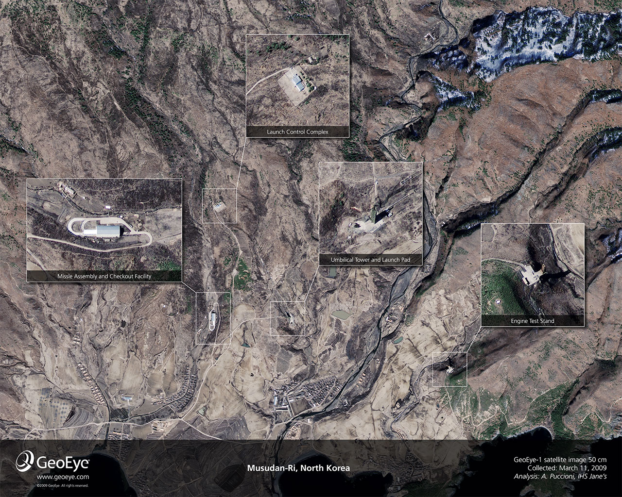
GeoEye, with the help of an analyst at IHS Jane's, has annotated the March 11 image for your viewing pleasure. The annotations spotlight the missile launchpad with its umbilical cord, the large Launch Control Complex to its north, the Missile Assembly and Checkout Facility just to its west, and an Engine Test Stand in a defile to the southeast.
North Korea says it will test launch a rocket, which it claims is designed to carry a satellite into orbit, in early April. The United States says it will not interfere with the launch, although Japan has said it will shoot the rocket down if it enters the country's airspace. U.S. officials including Defense Secretary Robert Gates contend that North Korea is interested in developing intercontinental ballistic missiles and this launch is part of that effort.
View the full-resolution image taken on March 29 or click the photograph below for the annotated image taken on March 11 detailing each area.
Both images courtesy of GeoEye Satellite Image.

During the Vietnam war Army recruits were taught that the North Koreans would shoot at you if you pointed a camera, or even just a finger, into their territory. If it is correct that the two missing American journalists were arrested/kidnapped for filming North Korea from the Chinese side of the border, then North Korea's attitude hasn't changed much in the last forty years; in fact, I have read about an exchange of machinegun fire across the border within the last year. Given the above, in the eyes of the hypersensitive North Koreans, this photograph demands a response. Given their demonstrated tenacity, I think we can expect to see North Korean satellite killers launched within five years. It will take longer for them to attack the Internet, but they must see the Internet, too, as a violation of their personal space.
Score: 0
|Is there something new here?
Of course they would prevent it IF they could! They cannot.
And as mentioned below, these peictures are not from military sources, which have MUCH more powerful imaging technologies at their disposal! This is avaibble from the same private sector sources routinely used by mining, logging, and many other companies.
What surprises me is that so few are aware of the existence of this technology in the PUBLIC sector - and it has been so for quite some time!
Just because its over North Korea does not make it new. In fact, how exactly do you think we have been montoring their nuclear capabilities and status for the past few decades???? Its not by sending someone to a border crossing and asking for updates.
I don't know if its directly related to the advent of the volunteer military and the fact that so many literally run to avoid service, but more would be much more aware of such common technical capabilities if they had indeed served in the military. Instead more seem to gain a sense of what they think is real from nonsensical movies.
Oh, and we don't even have to use satellites - if you only become aware of the CURRENT capabilities of UAVs (unmanned aircraft)! And no, not only are there a myriad number of types, but they are harder to detect and to shoot down than you might realize.
Score: -1
|You are worried about two stupid air head reporters who intentionally tested the North Koreans, when the American/Mexico border is fraught with killings, kidnappings and drugs. Man where is your sensibilities. Right now, North Korea is a safer border than ours.
Score: 0
|hey men, let it go.
Score: 0
|Sweet. I hope it goes over Japan. I want to see that sucker blown out of the air. lol
Score: -1
|It'll be interesting to see how this plays out.
I thought, however, that Japan only said they'd shoot it down if it looked like it would land (or any part of it land) on their soil.
Score: -1
|But think how Japan defines their territory -- aggressively, to say the very least. I'm thinking of Dokdo / Takeshima / Liancourt Rocks and how much trouble that's stirred up between Japan and South Korea. That dispute's off to the west, of course, and the missile is only expected to cross the northeastern prefectures, but you've got to wonder.
Japan today, meanwhile, is saying that if they feel like it's incoming they'll attempt first intercept above the atmosphere with the MSDF (maritime) destroyers; if that intercept fails, they'll have the air-defense guys (ASDF) go after it immediately before landing.
Score: 0
|Where's waldo?
Score: 2
|It seems very strange to me that I am able to see this on the Internet.
Score: 1
|Why?
Score: 0
|At this resolution and at this speed? That blows me away, I must admit. I'm hoping to make some time very soon to talk with GeoEye; they've always got fascinating stuff afoot and, hey, it would be fun to hear more.
Score: 1
|You think this is 'high' resolution?
For most 'official' uses this is considered unsatisfatory.
And the US only restricts that which compromises our security.
Score: 0
|I just am stunned that Satellite images of an enemy's military facility can be so easily obtained and posted. The resolution and its overall quality are also somewhat impressive considering this was shot hundreds of miles above the earth's surface. As someone who lived through the Cold War, it is a brain s*** to see the sense of entitlement to intelligence and public data.
Personally, I think it is AWESOME but it still shocks the hell out of me. Ok...now sign me up for the live HD feed of an F-22 Raptor in a dog fight.
Score: 1
|I think you are missing the point.
Most of these feeds are from civilian satellites! Not from what is capable of military resources.
You are NOT seeing the military feeds, and I can speak from first hand experience that what you see here pales in comparison to what is actually available.
The government may on occassion make available images sourced from military resources for political impact, but they are not routinely made available, and I can attest that what they will release also does NOT show the true capability of the systems.
You are seeing here is an example what any company or party can contract in the current private market.
Score: 0
|